Glacial Erosion
There are three main types of glacial erosion - plucking, abrasion and freeze thaw.

- Plucking is when melt water from a glacier freezes around lumps of cracked and broken rock. When the ice moves downhill, rock is plucked from the back wall.
- Abrasion is when rock frozen to the base and the back of the glacier scrapes the bed rock.
- Freeze-thaw is when melt water or rain gets into cracks in the bed rock, usually the back wall. At night the water freezes, expands and causes the crack to get larger. Eventually the rock will break away.
Glacial Landforms - Upland Features
Upland glacial features include:
- Corrie - This is an arm chair shaped hollow found in the side of a mountain, e.g. Helvellyn, Lake District
- Arete - This is a narrow, knife edge ridge separating two corries, e.g. Striding Edge, Helvellyn.


An arete - a knife-edged ridge separating two corries
Pyramidal Peaks - These are formed when three or more corries form in the side of one mountain, e.g. The Matterhorn, Austria or Mount Snowdon, Snowdonia National Park, Wales.

- Tarn - This is a lake found in a corrie, e.g. Red Tarn, The LakeDistrict.
Glacial Landforms - Lowland Features
Lowland glacial features include:
- U-shaped Valley - This a valley which was V-shaped but has been eroded by ice. The valley sides are steeper and the valley floor flatter after the ice melts. Hence the name U-shaped valleys.
- Truncated Spurs - These are spurs which have been cut through by ice, e.g. Nant Francon Valley, Snowdonia.
- Hanging Valleys - These occur when glaciers at higher levels than the main valley didn't experience such powerful erosion. Tributary streams enter the valley as waterfalls from hanging valleys.
- Ribbon Lakes - These are lakes found in U-shaped valleys, e.g. Lake Windermere, Lake District. Drumlins - These are hills shaped like eggs! (see diagram below).
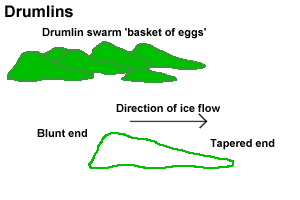
Drumlins are blunt at one end and tapered at the other. Drumlins are found in swarms called 'basket of eggs'topography. This is because they look like eggs in a basket! They are formed when ice is moving forward, but is also melting. The ice deposits boulder clay and till when it comes across a small obstacle (e.g. small rock outcrop). Most material is deposition the 'up stream' end of the drumlin. The down stream end is shaped by the ice.
Do you like this post? Please link back to this article by copying one of the codes below.
URL: HTML link code: BB (forum) link code: